ARCC

Team name
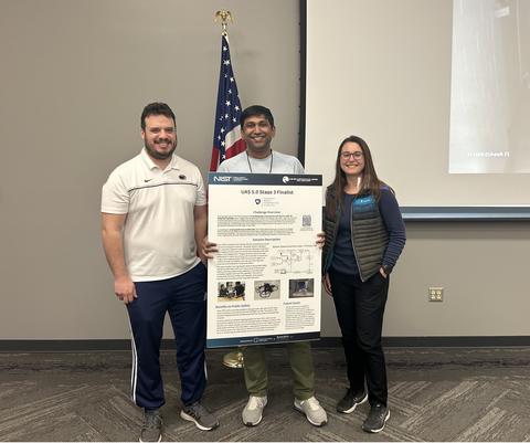
Team Autonomous Robotics Competition Club (ARCC) from Penn State University
Awards
- UAS 5.0: First Responder UAS 3D Mapping Challenge
- Stage 3:
- 2nd Place: $50,000
- Best-in-Class – Blue or Green UAS Capable: $5,000 (tied)
- Best-in-Class – First Responders' Choice: $10,000
- Stage 4 – Winner: $30,000
- Total 5.0 Prizes: $130,000
- Stage 3:
- UAS 4.0: First Responder UAS Indoor Challenge
- 4th Place: $30,000
- Total 4.0 Prizes: $50,000
- UAS 3.0: First Responder UAS Triple Challenge
- UAS 3.1: FastFind
- 2nd Place: $20,000
- Total 3.1 Prizes: $35,000
- UAS 3.2: LifeLink
- 1st Place: $40,000
- First Responder’s Choice Award: $5,000
- Total 3.2 Prizes: $60,000
- UAS 3.3: Shields Up!
- Final Winner: $30,000
- Total 3.3 Prizes: $35,000
- Total Triple Challenge Prizes: $130,000
- UAS 3.1: FastFind
UAS 5.0: 3D mapping solution summary
Team ARCC’s proposed solution was a two-vehicle solution comprising one aerial vehicle and one ground vehicle. The aerial vehicle was equipped with a powerful onboard computer and simultaneous localization and mapping (SLAM) system to provide first responders with clear views of the mapped area. The ground vehicle assisted the high-powered Wi-Fi system by carrying a Wi-Fi extender to extend the range of the mapping system. Both vehicles worked together to create a 3D map visualization with near real-time map data streamed and rendered on the ground station. The aerial platform had a gimbaled camera that provides 1080p and 60 fps video feed, and it could endure up to 20 minutes per battery with easy battery swap capability. It was durable with enclosed propellers and auto-flip capability. The avionics components were Green or Blue UAS Capable, which support thermal camera overlay and two-way real-time audio.

UAS 4.0: Indoor solution summary
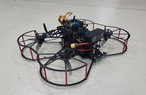
Team ARCC’s proposed solution was a platform (shown below)that performed search and rescue (SAR) missions, inspection and mapping missions, and other indoor tasks. The projected, overall system MSRP including the ground station, aircraft, avionics, and battery was $4,000. The platform was an X-configuration quadcopter that was small in size, allowing for operations in confined spaces. The selected configuration was a result of the design trade-off between endurance and maneuverability for indoor operations. The vehicle design was optimized to allow a high payload in terms of sensors that increase the versatility of the UAS by adding multiple features packed into a single solution. Appropriate selection of sensors allowed for a relatively low-weight system at 2.5 kg, which was comparable to other commercial solutions at the time.
The indoor navigation was based on a tracking camera that provided human pose information, allowing position hold flight mode. This feature was essential so that first responders can focus on identifying risks and locating survivors under collapsed structures instead of focusing on controlling the UAS. Additional range sensors in all four directions provided situational awareness for flying inside constricted space. A live video feed integrated with thermal images provided a complete visual solution to localize and detect people even in low light conditions; visible and infrared LEDs were used in similar situations. The visible LED was controlled by the operator while the infrared LED was automatically activated in low light conditions. Two-way radio communications provided an additional capability for first responders to communicate with any possible survivor. Propeller guards provided reliability for flying in an indoor environment.

UAS 3.1: FastFind solution summary
Team ARCC’s vehicle for the FastFind mission was a LiPo battery-powered hexrotor capable of autonomous waypoint following. The system’s main priority was to support first responder teams conducting SAR missions. The main sensor was an integrated FLIR Thermal camera to assist in “FastFinding” and identifying missing persons in visually obscured scenarios. Real-time video transmission of the thermal camera feed was available to a ground operator. A trained object detection algorithm combined both RGB and thermal camera feeds to help identify potential missing persons during flights and to save geo-tagged images for processing offboard in case further analysis was required. Quick battery swaps allowed the vehicle to fly longer than the estimated 26 minute endurance. The system was low weight and low cost which supports the requirements for a first responder operation. It had a small footprint for easy transport and was capable of being deployed by a single operator.

UAS 3.2: LifeLink solution summary
Team ARCC’s vehicle for the LifeLink mission was a LiPo battery-powered hexrotor capable of autonomous waypoint following. The system’s main priority was to support first responder teams conducting missions where network connectivity is otherwise unavailable. They demonstrated an integrated AyrMesh hub which was capable of transmitting internet protocol-based data to multiple first responder groups to disseminate voice communications, images, and video to each group. Each ground hub could be placed up to 2 miles away from the drone-mounted hub, although this was not demonstrated, and provide up to a maximum bandwidth of 10 Mbps to nearby devices. Quick battery swaps allowed the vehicle to fly longer than the estimated 26 minute endurance. The system was low weight and low cost which supports the requirements for a first responder operation. It had a small footprint for easy transport and was capable of being deployed by a single operator.

UAS 3.3: Shields Up! solution summary
Team ARCC’s solution focused on a scenario in which a public safety UAS is providing continuous broadband communications to first responders in a location without cellular coverage. Imagine a gradual spoof attack where fake GPS signals sent to the onboard GPS sensor cause the mobile station to drift far enough from its controlled hover position that communications become unavailable to the first responder team. The team’s countermeasure to this attack was to add a Visual Inertial Odometry (VIO) position data sensor to compare with GPS data for protection against GPS degradation or attacks on small, low cost UAS platforms. They modified the open-source PX4 flight control firmware to include the difference in GPS and VIO position data in the GPS quality checks. The autopilot switched to the backup position sensor when the GPS local position drifts far from the VIO sensor.

Team biographies
Vitor Valente received his Ph.D. in Aerospace Engineering from the Pennsylvania State University in 2024. He earned both his B.S. degree in Control and Automation Engineering and M.S. in Mechanical Engineering from Federal University of Rio Grande do Sul, Brazil. His research interests include flight control, performance and acoustics of Advanced Air Mobility (AAM) vehicles. He is a FAA certified remote pilot.
Rachel Axten is a NASA Pathways Intern and Ph.D. student in Aerospace Engineering at the Penn State UAS Research Lab (PURL). Her research interests include vehicle dynamics and fault-tolerant control. She is a FAA certified remote pilot and serves as the team's safety pilot.
Venkatakrishnan Iyer is a Ph.D. student in Aerospace Engineering at the Pennsylvania State University. He has a B.S. degree in Electrical Engineering from Mumbai University and a M.S. degree in Electrical Engineering from Penn State. His industry experience spans more than eight years, working at Hindustan Aeronautics Limited as a Systems Integration Designer for Helicopters. His current research involves dynamics and modeling of helicopters with development of adaptive control architectures and control allocation schemes.
Vidullan Surendran (team member in UAS 3.0 only) was a Ph.D. candidate in Aerospace Engineering at the Pennsylvania State University focusing on intent recognition in Human-Robot teams. He was an instructor for senior level courses on Advanced Programming Concepts in C++ and Software Engineering Techniques at the Penn State Aerospace Engineering department. As one of the founding members of ARCC, he participated in several vehicle platforms working on vehicle AI/decision making, software integration, electrical subsystem design and structural design.


