Summary
The Northeast Corridor (NEC) was established in 2015 as the third NIST urban testbed following those for Indianapolis and Los Angeles. The NEC project is currently quantifying greenhouse gas (GHG) fluxes throughout the urban areas of the U.S. Northeast, with a focus on the Washington and Baltimore urban areas.
Description

Northeast Corridor project elements
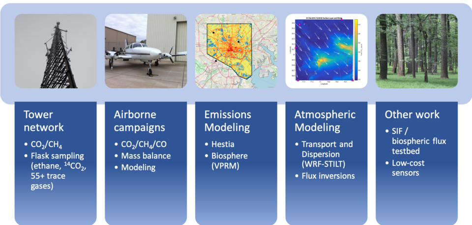
The NEC project includes multiple measurement and analysis components. The backbone of the NEC project is a network of in-situ CO2 and CH4 observation stations with continuous high-accuracy mole fraction measurements of these two greenhouse gases. In addition, the University of Maryland, Stony Brook University, and Purdue University conduct multiple-week flight campaigns periodically each year.
The NEC project also includes an extensive modeling component. First, high-resolution meteorological modeling (using the Weather Research and Forecast (WRF) model) is being conducted, with output coupled to Lagrangian dispersion models such as STILT and HYSPLIT. These transport and dispersion models are used to interpret observations from both aircraft and tower stations and are used in atmospheric inverse analyses to estimate fluxes in urban areas as well as the larger region covering the entire US Northeast and its upwind influences. A biosphere model is also being developed for the project as well as a high-resolution fossil-fuel CO2 inventory (Hestia).
NEC Tower Network

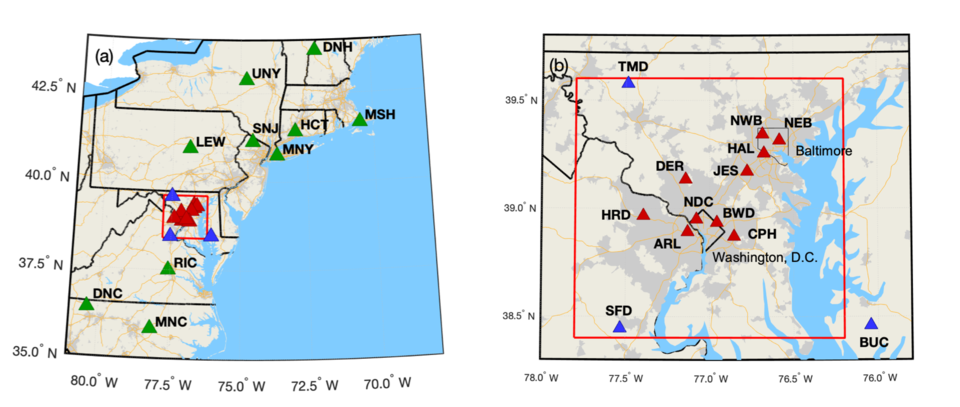
NIST has partnered with Earth Networks, Inc. to deploy tower-based CO2 and CH4 measurements in the NEC. Initially we have focused on a dense network around the Washington, DC and Baltimore, MD region, beginning in October 2015. We have established additional stations in neighboring states in the surrounding region, with plans to expand further to other cities. Tower-based continuous observations of CO2 and CH4 are calibrated to the WMO scales and reported with time-varying uncertainties, calculated in the manner documented in Verhulst et al. (2017) and Karion et al. (2020). Measurement data is publicly available and accessible at doi:10.18434/mds2-2491.

Whole air samples are collected in flasks at a subset of tower locations (MSH, NEB, NWB, BWD, and TMD) for analysis by NOAA/GML for hydrocarbon, halocarbon, and GHG species, as well as 13CO2 and radiocarbon. Work is also ongoing to incorporate medium and low-cost CO2, CH4 and air quality sensors into the network.
References:
Verhulst, K. R., Karion, A., Kim, J., Salameh, P. K., Keeling, R. F., Newman, S., Miller, J., Sloop, C., Pongetti, T., Rao, P., Wong, C., Hopkins, F. M., Yadav, V., Weiss, R. F., Duren, R. M., and Miller, C. E.: Carbon dioxide and methane measurements from the Los Angeles Megacity Carbon Project – Part 1: calibration, urban enhancements, and uncertainty estimates, Atmos. Chem. Phys., 17, 8313–8341, https://doi.org/10.5194/acp-17-8313-2017, 2017.
Karion, A., Callahan, W., Stock, M., Prinzivalli, S., Verhulst, K. R., Kim, J., Salameh, P. K., Lopez-Coto, I., and Whetstone, J.: Greenhouse gas observations from the Northeast Corridor tower network, Earth Syst. Sci. Data, 12, 699–717, https://doi.org/10.5194/essd-12-699-2020, 2020.
Related Links:

