
Official websites use .gov
A .gov website belongs to an official government organization in the United States.
Secure .gov websites use HTTPS
A lock (
) or https:// means you’ve safely connected to the .gov website. Share sensitive information only on official, secure websites.
Quantifying Firebrand Exposures for Wildland-Urban Interface (WUI) Ignition Potential
Summary
Wildland and Wildland-Urban Interface (WUI) fires pose a major challenge due to the large number of embers they produce. These embers, created by burning trees, plants, and buildings, can be carried by the wind over long distances. If they stay hot enough, they may ignite new fires, making firefighting harder. During large fires, it's common to see embers raining down on WUI communities, but we don’t fully understand the extent of the danger they pose, including how many embers fall, their size, speed, and heat. This project aims to improve how we measure ember showers and document firebrand exposure under different conditions. The data will help compare ember exposure levels, create more realistic lab tests, and improve fire spread prediction models. Ultimately, the goal is to use this knowledge to improve building codes and safety in WUI areas.
Description
Objective - To gather data to characterize both airborne (“flying”) embers – flux (a measure of a quantity in time and space), size/shape, and combustion state (glowing or flaming) - and deposited (“static”) embers – transfer of energy, loss of mass, and possible interactions occurring between embers - to support the development of metrics, laboratory tests methods and modeling tools to assess WUI ember exposures and their potential to ignite vegetation and structures.
Technical ideas/Research plans
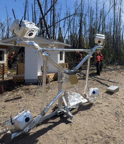
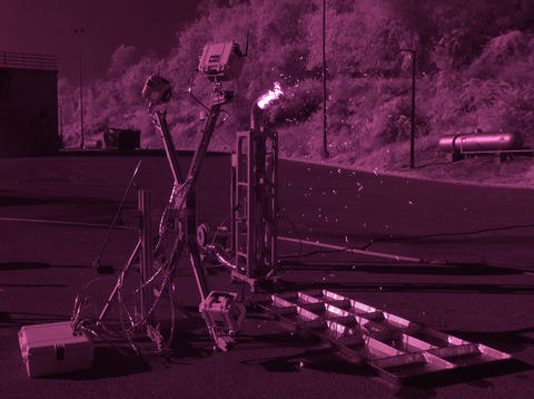
NIST Emberometer
- The Emberometer (video) is a camera-based system designed to study the motion of embers as they move through the air. It uses a technique called 3D Particle Tracking Velocimetry (3D-PTV) to track embers in three dimensions over time. This system can measure an ember 3D flux, i.e. how many embers pass through a certain area in a given time, a quantity valuable for comparing exposures. The system is also used to study the detailed motion of embers as they are about to land and settle, which may vary depending on the wind strength, nearby obstacles, etc.
- NIST Emberometers are currently being deployed during large-scale controlled fires to document ember exposures in various test conditions.
Ember Generators
- The measurement techniques from this project can help study ember generators. These generators are often used in laboratory test methods where ignition of vegetation and building materials is of interest. Typically, ember generators can produce flows of burning embers, but their output can be highly variable due to many control factors involved. The new measurement tools can help quantify what the variability may be and assess if the ember exposures created are different from what is observed in the field for large-scale fires.
- Efforts are ongoing to map the outputs of ember generators specifically designed to provide a continuous flow of embers over time.

Ember 3D Morphology
- Ember shapes and sizes are very important characteristics to better understand ember showers. For instance, both have a strong influence of the way an ember moves through the air, and they can also influence the way an ember burns when placed in a wind field. A new methodology, that relies on ember 3D digital models, has been developed to classify embers and help extract important morphology characteristics that cannot be accessed using traditional methods.
- Progress is currently being made to streamline this approach, allowing large samples collected during field experiments to be processed more efficiently.
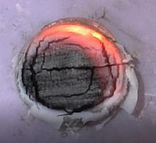
Ember Thermal Footprints
- The heat flux from an ember, or the amount of heat energy transferred from an ember, to the surface it is resting on is an important part of determining whether the surface will ignite. Researchers are currently measuring the heat flux from embers using thin-skin calorimeters in a laboratory-scale wind tunnel. The material of the ember, the wind speed, and the surface material are varied to see how these factors affect the heat flux.
- In other wind tunnels, further research is ongoing to explore how wind speed, wind temperature, and relative humidity affect the ignition of various fuels by multiple embers.
Major Accomplishments
- NIST measurement techniques have shown ember showers are complex phenomena, involving a broad range of scientific domains from combustion and heat transfer to aerodynamics.
- Innovative three-dimensional measurement techniques and methods have been developed to bring new insights and enable ember exposure comparison.