
Official websites use .gov
A .gov website belongs to an official government organization in the United States.
Secure .gov websites use HTTPS
A lock (
) or https:// means you’ve safely connected to the .gov website. Share sensitive information only on official, secure websites.
ISO/IEC 18305: 2016 – Introduction
Navigation
- Testing of Indoor Localization Systems
- Challenges of Testing Indoor Localization Systems
- Testing Facilities
- ISO/IEC 18305:2016
- Back to Location-Based Services portfolio page
Introduction
There exists a potentially large market for personnel / asset Localization and Tracking Systems (LTSs) in diverse application domains such as:
- emergency response;
- military;
- law enforcement;
- mining;
- E-911;
- offender tracking;
- personal vehicular navigation;

- smart phones / social networking;
- fleet management;
- asset tracking in factories / warehouses / hospitals;
- tracking the elderly / children; and
- personal navigation in museums / shopping malls.
Some applications of localization and tracking - such as personal navigation, fleet management, and asset tracking in factories / warehouses / hospitals - are commonly referred to as Location-Based Services (LBS). The use of LBS alone is expected to grow dramatically by 2020. Yet, lack of standardized Test and Evaluation (T&E) procedures has been an impediment to market growth for LTSs, because:
- potential users cannot easily determine whether these systems meet the users' requirements;
- it is hard to interpret T&E results when different metrics and procedures are used to evaluate a given system or even worse to evaluate different systems; and
- the use of disparate minimum performance requirements by various buyers / jurisdictions forces manufacturers to develop jurisdiction-specific products, thereby raising manufacturing costs.
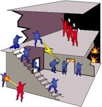
In contrast with LBS, there are many applications of localization and tracking that are essentially governmental functions in the sense that the government is the entity that is most concerned about the effectiveness of solutions for such applications. Examples of these applications include tracking firefighters entering a burning structure for command and control purposes and to launch a rescue mission if a firefighter becomes incapacitated, prevention of friendly fire when soldiers or Special Weapons And Tactics (SWAT) team members enter a building where either hostile forces or armed individuals threatening public safety have taken refuge, and guidance and navigation for missiles and precision-guided munitions. Many of these applications have more stringent localization accuracy and latency requirements than other applications of localization and tracking used by the general public, such as navigation in museums / shopping malls, tracking the elderly in nursing homes, ensuring children are not abducted from school grounds, and fleet management for a trucking company.
This document deals with T&E of LTSs. Once standardized T&E procedures have been established, it is possible to set minimum performance requirements for various applications of localization and tracking. For example, regulations promulgated by a government agency may require coal mine operators to have the capability to track the miners on duty within 5 m accuracy during normal mine operations and 100 m accuracy in the aftermath of a catastrophic incident in the mine, such as an explosion or a roof collapse. It makes sense to separate the T&E issue from minimum performance requirements, because the same T&E standard may be applicable to many applications of localization and tracking, but the minimum performance requirements typically vary from one application to another. This document deals with T&E only; it does not set minimum performance requirements for any localization and tracking applications.
T&E of LTSs is challenging for several reasons:
- Many systems work in a "networked" fashion. That is, several devices would have to communicate with each other in order to estimate the location(s) of one or more such devices. Therefore, the LTS performance is affected by how these devices are situated with respect to each other, i.e. by the network topology.
- The physical environment in which the devices are situated affects communications between them and functionalities such as ranging or estimating direction of another device and hence LTS performance. For example, Radio Frequency (RF) communications in a single-family house with a wooden structure is very different from that in a large high-rise building with a steel and concrete structure.
- Even though it is best to take a "black-box" approach to LTS T&E, one needs to be cognizant of the failure modes of various location sensors (such as Global Positioning System (GPS), RF ranging, RF direction of arrival estimation, accelerometer, gyroscope, and altimeter) that "might" be used in an LTS in order to design a comprehensive T&E procedure.
Yet another difficulty of a different nature is that some systems rely on the availability of a networking infrastructure, such as a Wi-Fi network, or other devices, such as Radio Frequency IDentification (RFID) or Real Time Locating System (RTLS) tags, to facilitate localization and tracking in a building or structure. Some allow deployment of such devices - sometimes called "breadcrumbs" - as users enter a building. Other systems are designed to function based on the assumption that they cannot get any help with localization and tracking from the building and breadcrumb deployment is not allowed. Therefore, the T&E procedure has to account for these possibilities or classes of LTSs.
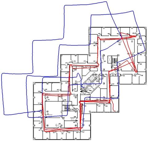
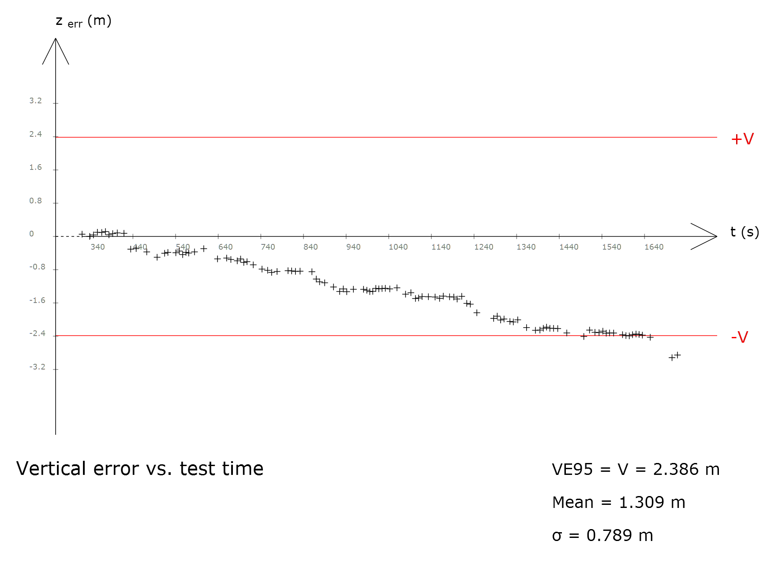
The main purpose of this document is to develop performance metrics and T&E scenarios for LTSs. LBS are envisaged in many application domains in both governmental operations and general public usage scenarios. Therefore, industry, consumers, trade, governments, and distributors are all affected by this document. Every effort has been made to write this document in such a way that it would be applicable to as many applications of indoor localization and tracking as possible. This document provides explicit instructions on how to report the T&E results, i.e. what information to document and what kind of tables and figures/plots to include to best visualize the results of the T&E effort. LTS T&E is complicated even once this document has been published, because there has to be a "network deployment" and testing in at least a few types of buildings. One should not expect that LTS T&E can be done in a laboratory. Performance results can depend on the particular building(s) used in the T&E procedure, but at least there will be a standardized way of doing the T&E, and if multiple LTSs are evaluated according to the standard in the same set of buildings, then the performance results can be compared. Localization and tracking technology has not yet matured. New systems and approaches will be developed in the next several years, but the T&E procedure can be standardized regardless of what takes place on the technology front and it may in fact foster technology development. In the absence of a T&E standard, the present uncertainties in the LTS market, where it is hard for users to ascertain whether LTS products meet their requirements and LTS vendor claims are hard to verify, will continue. Therefore, this is indeed the right time for development of this document.
Extensions of this standard to other application domains, such as miners trapped in an underground mine, navigation for submersible vehicles or tiny medical devices moving around inside a human body, may be the subjects of future standards that will be extensions of this "base" standard.
As a final note, the term "localization and tracking" has been used to denote the types of systems this document is meant to be applied to. However, this is not the only term in use for referring to such systems. ISO/IEC JTC 1/SC 31 uses the term RTLS, which also appears in the full name for this document. SC 31, in its deliberations, considered the use of the term "positioning" for the situations in which a person/object equipped with an appropriate device, uses that device possibly in conjunction with others and as part of a system to determine its own location. That is, "positioning" is for self-awareness. On the other hand, SC 31 regards "locating" as the appropriate term for the situation in which some other entity needs to determine the location of a person/object remotely. In other words, "locating" is for tracking and accountability purposes. There is also the possibility that a system needs to provide both "positioning" and "locating" functionalities (see 5.4.4), using the terminology just defined. "Tracking" is another frequently used term that has a time dimension to it. That is, one needs to keep track of a person/object's movements over a period of time. In its simplest form, tracking can be done by invoking a locating capability periodically over the time interval of interest. However, tracking can also take into account the mobility characteristics of the person/object being tracked. For example, it is highly unlikely that a firefighter would move faster than 1 m/s while putting the fire down in a burning building, and this information can be used to do a better job of estimating the firefighter's location at any given time. "Location System" is another term used in the literature. Yet another term, often encountered in military applications, is "navigation". In order to navigate a person/object to some destination point, it is necessary to know the person/object's starting location at a minimum. In case of navigating a missile or smart bomb, where missing the target or hitting something else can have catastrophic consequences, it is necessary to know the missile's/bomb's location continuously so that any deviations from its intended path/course can be corrected. Navigation includes computing a path to the destination. This path is not always the direct line from the starting location to the destination. For example, consider navigation in city streets or for providing guidance to a disoriented firefighter to get out of a burning building. Even though this document does not deal with navigation, it does deal with that component of navigation that has to do with where a person/object is at a given time.
This document adopted the term "localization" to capture both locating and positioning functionalities, because the person/object has to be "localized" in either case. It also adopted the term "tracking" to ensure the standard is not just about a snapshot of person/object's location, but also addresses its evolution over time. As a matter of fact, SC 31 has so far focused on purely RF-based systems, but this document considers systems that may use a variety of sensors for localization and tracking, including Inertial Measurement Units (IMUs), whose performance is indeed affected by how the person/object is moving.